

Profile of Katori City
更新日:2025年9月29日
Katori City is located in the northeast corner of Chiba prefecture, and northern part of the city borders Ibaraki Prefecture. Katori City is located 70km from Tokyo and 15km from Narita Airport.
The Tone River runs from west to east in the northern part of the city, from which the nearby towns take the name "Suigo" (or "riverside district"). The southern part of Katori City is located on the Hokuso Plateau, and consists mainly of forests and fields.
Thanks to its mild climate and rich soil, Katori is famous for rice and provides metropolitan areas with food. This has been a role that Katori City has held for centuries.
Katori City is rich in nature, history and culture. The pastoral landscape and Satoyama (communities where nature and people coexist) convey the beautiful scenery of old Japan. The natural scenery around the Tone River and Sawara's Historical District paint a picture of Katori City's original role in Japanese commerece during the Edo Period and onward, a merchant town abundant in natural resources and waterways for transportation. You can even visit the townhouse in which Inoh Tadataka, a famous merchant who lived most of his life in Sawara, credited with the creation of the first accurate map of Japan duering the Edo Period.
City Emblem

The City Emblem for Katori City represents the waterside scenery, expansive rice paddies, the senic nature of the Satoyama, and the blue sky spreading out toward the future. The emblem resembles the letter “K", the initial letter of Katori City, and also was made to look like a bird flapping its wings.
This lively shape symbolizes the beautiful nature and the continued progress of Katori City. (Established September 3rd, 2006)
City Flower, Tree and Bird
City Flower (Iris) "Ayame"
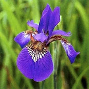
The iris is a popular flower among citizens of Katori city. They can be found in abundance around Katori's waterside areas, such as the Tone River, the Ono River, the Kurobe River and the Kuriyama River.
Suigo Sawara Ayame Park is home to over 1,500,000 million irises and is a major tourist attraction, with visitors coming from all parts of Japan. The irises bloom during June, and are a sight to behold.
Accordingly, when Katori City was established in 2006, the iris was designated as the official city flower.
City Tree (Cherry Blossom) "Sakura"
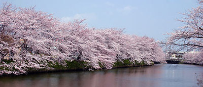
There are many spots in Katori City famous for cherry blossoms, such as Suwa Park, Joyama Park, Tachibana Fureai Park, and Katori Jingu Shrine.
The cherry blossom was selected as the official city tree in hopes of improving Katori City's image, with the goal of planting more in the future.
City Bird (Reed Warbler) "Yoshikiri"
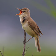
The Reed Warbler is well known to citizens of Katori.
In Japanese, these birds are known as "Yoshikiri".
The Reed Warbler is often associated with wetlands and marshes, which is fitting for a major waterside city like Katori. This bird has often been the center of many poems and Haikus, and they are known to sing very merrily.
このページの作成担当
商工観光課 観光班
〒287-8501 千葉県香取市佐原ロ2127番地 (市役所3階)
電話:0478-50-1212
ファクス:0478-54-2855